 We all know the old real estate adage: “Location, location, location.” In commercial and industrial construction, the saying goes beyond proximity or curb appeal. When it comes to design, one of the major ‘location’ considerations is seismic site classification. Several of the design parameters relative to site location can be determined by reviewing the Building Code Risk Coefficient Maps which are based on proximity to known seismic zones, however the specific subsurface conditions at the project site must also be determined. Even in areas relatively far away from known active seismic areas, the cost associated with seismic design can have a significant impact on the cost of the structural framework of the building. The biggest variable in the equation is the Site Class.
The Site Class is based on the average conditions present within 100 feet of the ground surface, and are designated as A-F, with hard rock, considered an ‘A,’ down to potentially collapsible soils, which get an ‘F.’ The Site Classification is based on shear wave velocity. For the A and B classification, it is preferable to measure the shear wave velocity on-site. The Building Code does allow the design condition to be estimated by a geotechnical engineer, engineering geologist or seismologist, with significant past knowledge of specific geologic formations and conditions (considering weathering and fracturing). Site Classes C, D and E can also be determined by seismic methods or typical soil drilling Standard Penetration Test (SPT-N) results. Site Class F is used for potentially collapsible soils, usually soft alluvial deposits.
Due to the cost of the exploration required to accurately determine the Site Class versus the relative additional cost to the structure, (savings on the order of 100x the cost of the analysis have been realized!) it is prudent to evaluate the upper 100 feet using soil drilling methods or seismic methods. Due to the relative quickness and ease and accuracy in which the seismic data can be obtained, the seismic method is typically more cost effective. Additionally, the building code limits SPT-N values to 100 if rock is encountered in the upper 100 feet, so when rock is present, it is not uncommon to improve the Site Class using seismic data relative to data from soil test borings. Pre-construction knowledge of the soil’s capabilities not only keeps everyone in compliance with International Building Code, it makes good business sense.
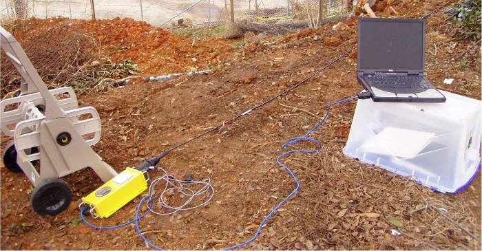
Building & Earth surveys are conducted using SeisOpt’s® patented Refraction Microtremor (ReMi®) technology.
This surface-performed geophysical survey evaluates surface waves, shear waves in particular. These dispersive waves are measured along a linear seismic array and evaluated relative to wave frequency and slowness. A seismograph, geophones placed in an array, and a seismic source are used to measure the propagating waves, all while data is recorded. This information is used to generate a 1-D subsurface profile based on the velocity with depth.
We’ve found that ReMi technology has some measurable advantages, including:
• Tests a much larger volume of the subsurface, in contrast to borehole measurements.
• Non-invasive and nondestructive, and uses only ambient noise as a seismic source.
• No permits are required for its use.
• No need to close a street or shut down work for the purpose of data acquisition.
• Usually takes less than two hours, from setup through breakdown.
The technology can also be used to determine liquefaction potential, soil compaction and subsurface geology.